How Solar Developers Screen Land Without Driving Every County
Utility-scale solar screening eliminates 99% of parcels before a site visit. Here's how developers use parcel data to run that filter stack in hours instead of months.
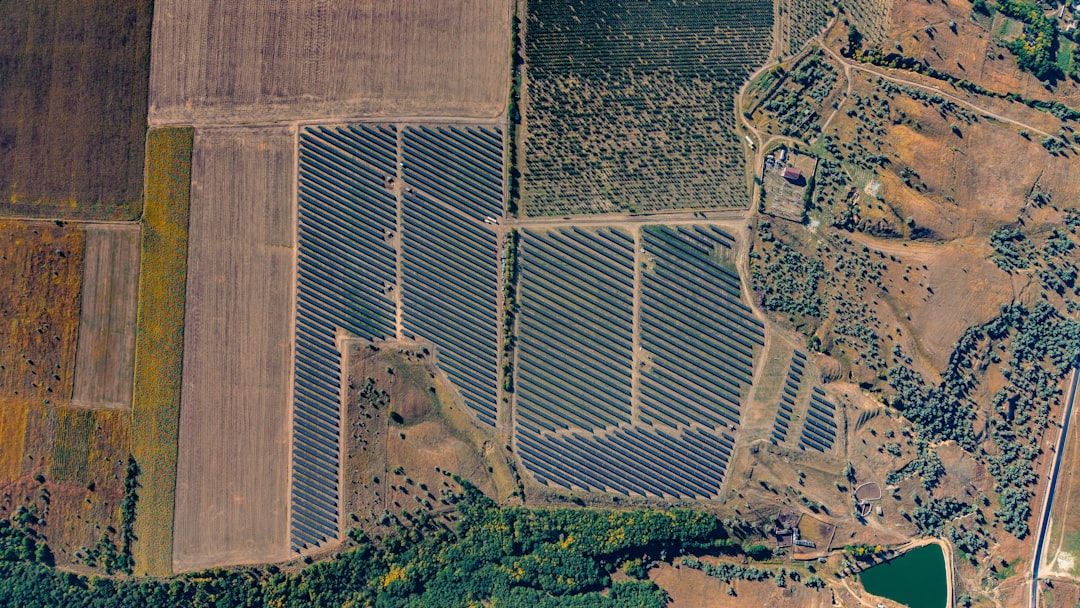
Identifying a single viable utility-scale solar site means reviewing thousands of ineligible ones. Projects need 500–700 acres of contiguous, buildable land within a few miles of transmission — a combination that eliminates roughly 99% of parcels in any given county before a developer sets foot on-site.
The old workflow was field-based: county office visits, plat book reviews, calls to assessors. A regional screening for a 100 MW project could take months. Parcel data compresses that to hours.
Here's how the filter stack works.
Clean Geometry First
Before any analysis, you need accurate parcel polygon boundaries — actual lot lines, not centroids or county outlines.
Utility solar requires contiguous land. A 600-acre project typically spans 8–12 adjacent parcels with different owners. If your geometry has overlapping boundaries, coordinate errors, or missing rural parcels, adjacency analysis produces false positives that cost money downstream.
Most public county GIS data has all three problems. Some assessors update geometry quarterly; others haven't touched it since 2015. Screening across multiple states means stitching together dozens of independent datasets with inconsistent coordinate systems, field names, and update frequencies.
Clean, normalized geometry is the prerequisite — everything else depends on it.
Filter 1: Size and Ownership Clustering
The first pass removes the obvious mismatches. For utility-scale solar, that means filtering for parcels above a size threshold (commonly 50 acres) and identifying contiguous clusters where adjacent parcels sum to the project target.
Ownership clustering matters as much as acreage. A 600-acre cluster spanning 12 parcels owned by 12 separate entities is a different negotiation than the same acreage across 3 family-owned farms. Parcel ownership data surfaces this before you've made a single call.
The mailing address on record also matters: it tells you whether the landowner is a local farmer, a timber company, or an out-of-state investment fund — each requires a different outreach approach.
Key fields at this stage: acreage, owner_name, mailing_address, parcel_id.
Filter 2: Transmission Proximity
Good solar resource means nothing without grid access. The national interconnection queue now exceeds 2,000 GW of projects waiting for study — sites near existing substations and transmission lines have a real advantage in both timeline and project economics.
The practical filter: a 2–3 mile buffer from 69kV+ lines covers most viable interconnection distances before costs become prohibitive. Beyond 5 miles, transmission extension often costs $1M/mile or more.
| Transmission proximity | Typical cost impact |
|---|---|
| Within 1 mile of existing substation | Lowest cost, shortest queue |
| 1–3 miles from 69kV+ line | Standard interconnection study |
| 3–5 miles | Line extension likely required |
| 5+ miles | Often project-killing cost adder |
Costs vary by utility territory and queue position. Use as a directional filter, not final project economics.
Parcel data provides the geographic reference layer for this analysis. Buffer the transmission network, intersect with candidate clusters from Filter 1, discard everything outside.
Filter 3: Buildable Area and Exclusions
Gross acreage overstates usable land. Floodplains, wetlands, steep slopes (typically >5% grade for ground-mounted solar), and habitat buffers all reduce the buildable footprint.
The intersection: take candidate parcel polygons and overlay FEMA Special Flood Hazard Areas, USFWS National Wetlands Inventory, and USGS slope data. What remains is the net buildable envelope.
A 100-acre parcel with 40 acres in a FEMA Zone AE is a fundamentally different opportunity than a clean 100-acre dryland parcel. Running this intersection at the screening stage prevents sites from advancing that can't support the required capacity.
At 5–7 acres per MW for ground-mounted utility solar, a 100 MW project needs 500–700 net buildable acres after exclusions. That's the real target, not the gross parcel area.
What the Full Workflow Looks Like
A developer entering a new market — screening across a five-county region in the Southeast, for example — typically runs:
- Load parcel data for all five counties into ArcGIS, QGIS, or PostGIS
- Filter: parcels > 50 acres
- Build adjacency graph: identify touching parcel clusters
- Sum cluster acreage: flag clusters ≥ 500 acres
- Overlay transmission buffer: keep clusters within 3 miles of 69kV+
- Apply exclusion layers: subtract flood, wetland, and slope constraints
- Calculate net buildable acres per cluster
- Export ranked candidate list with owner names and mailing addresses
The output is 15–30 sites worth a phone call or visit, out of thousands of parcels reviewed. That ranking is only as good as the geometry and ownership data underneath it.
What Data Quality Actually Costs
Parcel data errors have direct financial consequences at every stage.
Boundary errors create false adjacency — two parcels that appear to touch in the data but don't in the field, or overlapping polygons that look like one parcel but are legally two. Sites advance through screening that shouldn't.
Missing rural parcels leave gaps in coverage. Agricultural land that hasn't changed hands in decades is often underrepresented in county GIS files, particularly in the Southeast and Midwest where some of the best solar land sits.
Stale ownership records send outreach to the wrong contact. A landowner who sold five years ago still appears as current owner; the developer burns time on a call that goes nowhere.
None of this is unusual when working from raw county GIS files. Stitching together data across multiple jurisdictions without normalization produces all three problems routinely.
GetParcelData for Solar Screening
GetParcelData provides normalized parcel data for 160M+ parcels across all 52 states and territories. For solar developers:
- Clean geometry: polygon boundaries with validated topology, no overlapping parcels
- Standardized fields:
parcel_id,acreage,owner_name,mailing_addressin a consistent schema regardless of source county - Rural coverage: counties where public GIS is incomplete or years out of date
- Multiple formats: Shapefile, GeoJSON, GeoPackage, or API access for direct PostGIS integration
Sample data is available for 2–3 counties in your target region. Load it into your existing GIS, apply your standard filters, and see what the data quality looks like for your specific market before committing.